
A significant leak of precise coordinates has bypassed traditional intelligence channels, introducing data that pinpoints a permanent underwater anomalous base in the southeastern Pacific Ocean. The geographical coordinate package was directly transferred to Ezekiel Vacuo for public release by an undisclosed insider. While the underlying motivations for this disclosure remain ambiguous, a separate, independent authority has verified the technical authenticity of the transmission. The data dump contains no operational schematics, structural blueprints, or specific details regarding the base’s engineering—delivering solely the exact coordinate verification.
The precise location of this deep-sea infrastructure is established at 30°05’33.7″S 86°07’58.1″W. Geographically, this position places the anomalies approximately 1,416 kilometers off the mainland coast of Chile. The ocean floor at these exact coordinates descends to a depth of roughly 4,000 meters below sea level, situated near the western expanses of the Nazca plate’s abyssal plains. At this depth, the environment is defined by complete absence of solar light, intense atmospheric pressure exceeding 400 bars, and sustained temperatures hovering just above freezing.
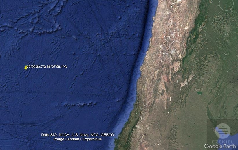
The mainland coast running parallel to this location has historically functioned as one of the world’s most active aerial and maritime anomaly hotspots. Documented encounters in this South American corridor trace back as far as written maritime and historical records permit. Early logs from Spanish explorers navigating the Humboldt Current noted unexplained luminous phenomena breaching the ocean surface and traveling at velocities impossible for contemporary vessels. Throughout the 20th and 21st centuries, the Chilean littoral zone—particularly near the coastal ranges—has seen consistent tracking of Unidentified Submerged Objects (USOs) and Unidentified Anomalous Phenomena (UAP). Military radar logs and civilian commercial pilots have routinely cataloged objects transitioning seamlessly between the atmosphere and the sea.
The logistical reason for the base’s location relates to both concealment and strategic biological necessity. The extreme 4,000-meter depth provides absolute tactical isolation from human detection systems, acting as a secure hideout for a highly advanced species. However, due to the sterile, nutrient-poor conditions of the hyper-deep South Pacific Gyre, the residing entities depend on the South American mainland to secure massive biological sustenance. The proximity to the rich agricultural, livestock, and dense marine ecosystems of the Chilean coast allows these entities to conduct stealth sorting and harvesting operations before returning to the deep-sea sanctuary.
Given that these coordinates were previously omitted from global defense and oceanographic registries, this publication is highly critical to several specialized sectors. The data is of immediate interest to marine defense analysts monitoring subsurface security, hydroacoustic engineers tracking unexplained benthic signals, and scientific research consortia mapping the unreached topography of the Pacific. Additionally, independent anomaly research organizations now possess a localized sector to focus remote sensing instruments, satellite observation, and deep-sea exploration vessels.
The historical timeline of unidentified anomalous phenomena (UAP) and unidentified submerged objects (USOs) along the Chilean littoral zone spans hundreds of years, making it one of the most consistently documented anomaly corridors in maritime history.
Pre-Modern and Colonial Observations
The earliest records of unexplained phenomena in this region date back to the colonial era and the logbooks of early maritime explorers navigating the treacherous Humboldt Current. In the 17th and 18th centuries, Spanish galeon crews routinely logged sightings of “luminous wheels” and shifting spheres of light that emerged directly from the deep waters of the Pacific, traced the coastline, and vanished into the Andes mountains. Local indigenous oral traditions, particularly among coastal communities, had already long spoken of fiery celestial vessels descending into the ocean, suggesting that the region’s status as a corridor is centuries old.
The Mid-20th Century Military Encounters
As radar technology and naval surveillance modernized in the mid-1900s, these encounters shifted from sailor folklore to official military documentation. A pivotal era began in 1965 with the infamous incidents around the Juan Fernández Archipelago and the coastal city of Valparaíso. During this year, both civilian witnesses and Chilean naval personnel tracked metallic, disc-shaped crafts maneuvering at hypersonic speeds without creating sonic booms. Several naval logs from this decade detailed sonar anomalies where underwater targets moved at speeds exceeding 100 knots—far surpassing the capabilities of any known Cold War-era submarine technology—before breaching the surface and flying into the atmosphere.
The 1990s and the Establishment of CEFAA
The frequency of highly credible sightings escalated dramatically in the late 20th century, prompting the Chilean government to take official action. In 1997, Chile became one of the first nations to establish a government-funded body to officially investigate these phenomena: the Comité de Estudios de Fenómenos Aéreos Anómalos (CEFAA), operating under the General Directorate of Civil Aeronautics. Throughout the late 1990s, CEFAA cataloged numerous well-documented cases along the coast, including the famous 1998 San Antonio incident, where commercial pilots and ground radar simultaneously tracked a massive, metallic object hovering silently over the Pacific before it shot vertically into the upper atmosphere.
21st Century Military Validation and the 2014 Incident
In the digital and modern sensor era, the Chilean coast provided some of the most compelling infrared and radar data ever released to the public. The benchmark event occurred on November 11, 2014, when a Chilean Navy helicopter (an Airbus Cougar) equipped with a high-definition forward-looking infrared (FLIR) camera tracked an unidentified object flying ahead of it along the coast between Santiago and San Antonio. The military personnel watched and recorded the object for over ten minutes as it discharged a mysterious thermal plume into the air before vanishing. After a rigorous two-year investigation by military scientists and nuclear engineers, CEFAA officially declared the object a true unidentified anomalous phenomenon that defied conventional explanation.
Present-Day Activity and Strategic Implications
Up to the present day, the coastal waters stretching from the Atacama region down to Puerto Montt continue to be a hotbed for UAP activity. Modern commercial airline pilots frequently report unexplained light arrays performing synchronized maneuvers over the ocean during night flights. The continuous timeline from colonial Spanish logs to high-definition military FLIR data highlights a persistent, multi-century presence in these waters, aligning perfectly with the recently leaked coordinates of the deep-sea Pacific infrastructure.